
The Journal of the Pembrokeshire Historical Society
Cylchgr awn Cymdeithas Hanesyddol Sir Benfro
Number 15
2006
Editor
Roger Turvey, B.A., Ph.D., PGCE, FSA, FRHist.S
© Pembrokeshire Historical Society 2006
ISBN 0-903771-06-3
Printed by
Gwasg Dinefwr Press, Llandybie, Carrus.
PREHISTORIC FUNERARY AND RITUAL SITES
IN PEMBROKESHIRE
By Nikki Cook
INTRODUCTION
Recent fieldwork in Pembrokeshire has focussed on visiting all known Neolithic and Bronze Age ritual and funerary monuments within the county. During this fieldwork a number of new sites were discovered and additional information recorded for the previously known sites.
Between January 2003 and February 2004 Cambria Archaeology undertook a rapid assessment of the form and condition of all known prehistoric funerary and ritual monuments dating from the Neolithic and llrnn1.c Ages throughout Pembrokeshire, as part of a pan-Wales project funded by Cadw involving all four Welsh Archaeological Trusts.’ The pri nci pal objectives of this survey were the enrichment of the Regional Sit es and Monuments Record (the SMR) and to contribute to Cadw’s Scheduled Ancient Monument (SAM) enhancement programme.
One of the ways in which these principal objectives was achieved was by conducting an examination of the surviving physical evidence for all the different monument types which fell within the remit of the proposed project. During the Neolithic and Bronze Age (which dates from approxi mately 4400BC for the early Neolithic through to c.1300BC.for the end or the middle Bronze Age, a variety of different monument types were built, which were either used for the burial of the dead or were connected with the rituals that took place surrounding death at this time. The earliest of these monuments were megalithic chambered tombs (a well known example being that of Pentre Ifan, near Newport). At the time when these monuments were built the trend was towards collective burial of individuals , although it is clear that not all members of society were treated in this way. The processes and rituals which surrounded death and burial in the Neolithic and Bronze Age were highly complex and changed gradually during this period, and the developments in monumental architecture would seem also to reflect these trends.
In simplified terms, at the start of the Neolithic dead bodies were gener ally placed into the chambers of megalithic tombs once they had been defleshed, i.e. the cleaned bones of individuals were gathered together and interred, with the dead body believed to have gone through a variety of different rites before most (but not all) of the disarticulated bones were finally (and often selectively) deposited. This has led archaeologists to suggest that early Neolithic society was perhaps largely egalitarian (the bones of men, women, children and foetuses all included in burial rites, though not necessarily together), where there was the denial of individuality in death which reflected a belief instead in a communal set of ‘ancestors’. Evidence from anthropological contexts suggests that these ancestors were believed to ‘govern’ the fortunes of the living, control ling, for example, their ability to procure food or be healthy, and as such these ancestors needed constantly to be appeased and venerated through successive rituals at the same locations.
Although the Neolithic is generally thought to be the time of the first farmers, it is highly likely that to start with people still lived a fairly nomadic lifestyle, moving between upland and lowland pastures herding animals. As a result the evidence we have for actual settlements is quite scanty2 when compared with that for ritual/funerary monuments . It is clear that people in the Neolithic possessed the. ability to build lasting architectural forms, as evidenced by the numerous chambered tombs seen within Pembrokeshire, but their lifestyle meant they had no need to build lasting domestic dwellings. However, chambered tombs were able to act as fixed places in the landscape where people could periodically gather together, reaffirming their ‘collectivity’ through the performance of rituals involving the bones of the communal ancestors and this in turn would serve to reunite the group. Therefore it is important to see these monuments as much as places for the living as they were for the dead, and they fulfilled a role far greater than just a place where dead bodies were placed. Also, as places of collective burial these megalithic tombs were used time and time again, sometimes for hundreds of years, before they went out of use and were sealed up, or deliberately emptied of their contents and abandoned. There were successive phases of activity at chambered tombs, which often saw previous internments moved and rearranged as new additions were made. Excavations have provided evidence for a variety of rituals which accompanied the deposition of bodies within the tombs, including the lighting of fires, feasting, and the structured placement of grave goods such as pieces of pottery and items of flint. This strengthens the interpretation of the tombs as foci for the living, where they could gather together for the reaffirmation of social and religious bonds as much as to celebrate their omnipotent ancestors.
Later in the megalithic tomb sequence towards the middle-late Neolithic ( c.3000BC), as chambered tombs were falling out of fashion, dead bodies began to be placed into the monuments whilst still intact, suggest ing that there was a move away from previous expressions of collectivity towards the celebration of the individual. However, it wasn’t until the beginning of the Bronze Age (c.2300BC) that individual burials were more commonplace, and by then monumental architecture had changed completely. Round barrows were now the dominant form of funerary monument, and certainly to begin with these monuments appeared to be constructed for the sole internment of an individual, inhumed intact, often in a crouched position and accompanied by a very specific type of pottery. At the same time, life for the living was becoming largely more sedentary than nomadic, and it is during the Bronze Age that we see the shift towards structured settlement and more permanent domestic structures. Even so, the archaeological evidence for such domesticity in west Wales remains largely elusive, due to its ephemeral nature and is generally encountered by chance. Again, there is no such impermanence with the funerary and ritual monuments of the period, which were clearly built to last. At the same time as monumental architecture was changing, which perhaps reflected changing trends in perceptions of life and death, so too were ways of dealing with dead bodies. During the late Neolithic we see the start of the first cremated remains, with some cremations included for burial within chambered tombs, before these sites were abandoned completely as the new monument forms took their place. Many round barrows, for instance, contained a central (primary) cremation burial interred within (often inverted) pottery vessels, with other ‘satellite’ cremation burials included around the outside of the mound. However, other round barrow sites initially covered the articulated inhumed remains of an individual, buried in a shallow pit or within a stone-lined cist, with secondary cremated deposits then added into the body of the cairn at a later date. As was the case with the chambered tomb tradition, round barrows too acted as foci for repeated acts of ritual and deposition: they were not one-off events, despite their more ‘closed’ architecture. However, with round barrows, regardless of the funerary rite, it seems that at the outset these monuments were clearly intended to mark certain individuals, often with grave goods accompanying these burials. This has led to the assumption that these mounds were the tombs of important people, such as ‘chieftains’, and that this indicates a shift in social structure as groups settled down into a more sedentary farming lifestyle, requiring a more hierarchical form of social order.
Between the advent of chambered tombs and their supersedence by round barrows there lies a whole host of other ritual/funerary monument forms, such as henge monuments, standing stones, stone circles, and ring cairns, all of which are discussed later in this paper.3 In the absence of comparable amounts and quality of settlement evidence, the changing nature of ritual and funerary monumental architecture remains the sole indicator of social activity in the prehistoric past, and forms the basis on which our interpretations about the lifestyles and beliefs of our ancestors are founded. During the Prehistoric Funerary and Ritual Sites (PFRS) survey a full review of all available evidence including artefacts and previous excavations and fieldwork was beyond the scope of the project. However, for the purposes of this paper, and in order to place the various types of monuments in a wider context, an indication is provided in the text of the more important excavations and discoveries from the Pembrokeshire region, and other parts of southwest Wales. In visiting and recording all the known Neolithic and Bronze Age funerary and ritual sites it is hoped that we can reach a greater understanding of these enigmatic monuments, as well as preserve them for the enjoyment of future generations.
SURVEY RESULTS
A total of 612 sites were assessed during the fieldwork phase of the PFRS project, 36 of which were newly discovered sites, including 15 standing stones, 6 ring barrows, 3 round barrows and two chambered tombs.
Individual site types, definitions and numbers
Chambered tomb (Fig. 1 – 82 sites, Plate 1) – a monument with evidence of a burial chamber, and occasionally a passage, comprised of upright stones and considered to be a funerary and ritual monument of the early- middle Neolithic period (c.4400-3200BC). The burial chamber may be covered by a capstone or roof stones and may be enclosed within a round or long mound or cairn. The burial chamber is generally larger than, and distinct from, a cist.
There are 82 chambered tomb sites known in Pembrokeshire, of which 45 are definite examples. With no extant chambered tomb sites recorded in Ceredigion, and only 15 definite examples known for Carmarthenshire, Pembrokeshire was clearly an important focus of funerary and ritual activity in the Neolithic, which can perhaps partially be explained by its coastal zone offering abundant resources, which had been populated during the preceding Mesolithic period and continued to be exploited during the new stone age. Many chambered tombs in south west Wales have been investigated at some time in their history, amongst the most recent being Carreg Coetan Arthur, Newport ,4 Carreg Samson, Abercastle,5 and prior to that, Pentre lfan.6 At Carreg Samson funerary material included part of an unburnt leg bone beneath a fallen orthostat lying on top of a stone pavement, whilst beneath the paving lay an earlier layer of unburnt bones pressed into the natural clay floor.7 Other finds recovered included burnt bone and pottery from the chamber floor, and flint artefacts from the chamber fill, passage area and amongst stones close to the chamber. Two radiocarbon dates from the monument in the region of 3700BC places the site firmly within the later part of the early Neolithic. At Carreg Coetan Arthur, cremated bone was found amidst pottery apparently laid on a stone pavement outside the chamber, which was discovered under a surviving section of mound material. A stone kerb enclosing the tomb also covered scatters of cremated bone and pottery, whilst a small number of flint artefacts were found at various parts of the site.8 Four radiocarbon dates were obtained Carreg Coetan Arthur which indicated a range of c.3700-3000BC for various phases of activity at the site, the earliest date coming from charcoal sealed by the stone kerb, with the old ground surface sealed by the mound dated to c.3250BC, placing this site more firmly within the middle Neolithic
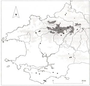
Fig. I/Plate I- Chambered tombs.
Solid symbols = probable sites. Open symbols = possible sites. Land over 100 m and 250m js represented by shaded areas.
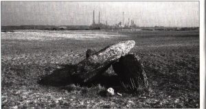
period. Barker has recently reviewed the evidence for chambered tombs in southwest Wales,9 whilst Cummings and Whittle have discussed Pembrokeshire chambered tombs and their landscape setting within the wider context of their study of the Welsh Neolithic. 10 However, the ‘phenomenological’ approach taken by Cummings and Whittle has been recently critiqued in an excellent article by Andrew Fleming. 11
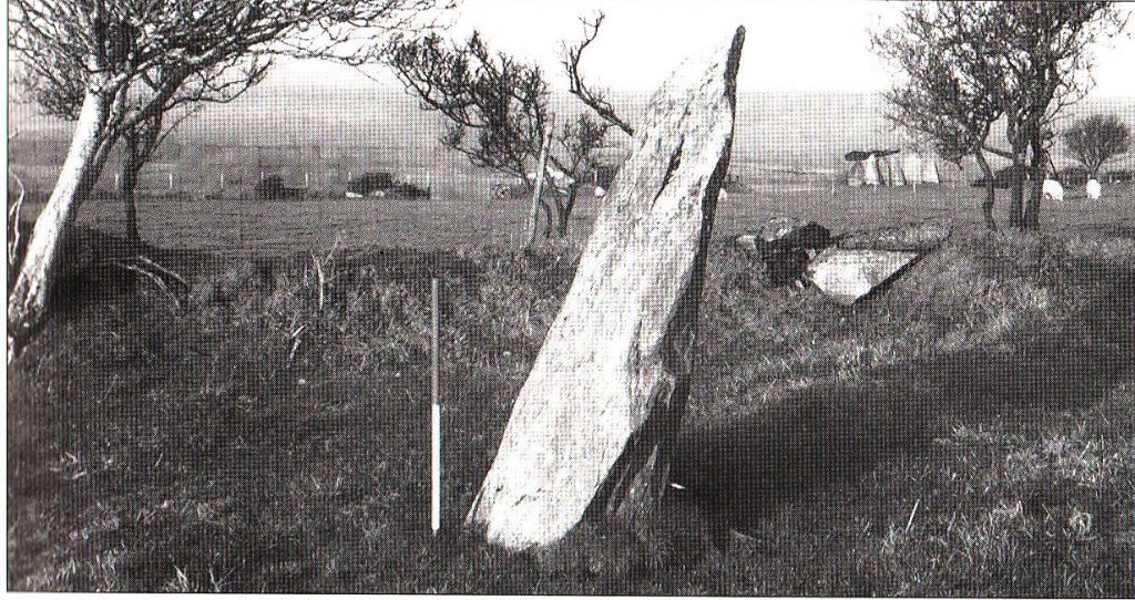
Standing stone (Fig. 2 – 159 sites, Plate 2) – defined as a singular up right monolith or boulder set in the ground and assumed to be a ritual monument of prehistoric date. Recumbent stones are included as a sub type within this monument class.
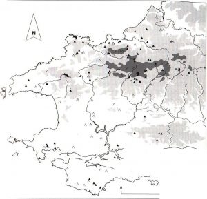
Fig. 2 – Standing stones.
Solid symbols = probable sites. Open symbols = possible sites. Land over 100 m and 250m is represented by shaded areas.
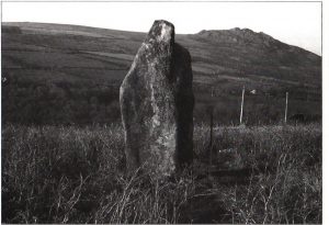
Plate 2 –Standing stone.
Standing stones are often, though not always, associated with other ritual and funerary monuments of Neolithic and Bronze Age date and may also be the focus of ceremonial activities including the use of pits and timber structures, the lighting of fires and also acts of structured deposition. Such features are not visible above ground, and are only recorded as the result of excavation. Twelve new sites were discovered during fieldwork, bringing the total to 97 certain and 62 possible sites. Several standing stone sites have been excavated in southwest Wales, with particularly good results at Stackpole Warren in south Pembrokeshire. 12 Excavations here demonstrated the complex and extensive below ground remains that can survive around standing stones, and included an alignment of water worn boulders, a stone setting, a cremation pit, and numerous other features,’3 as well as a wealth of finds including pottery from a number of different vessel types, and items of worked flint and stone. The cremation was securely dated to the Bronze Age with a radiocarbon date of c.1540BC. The site also continued to be the focus of ritual/funerary practice into the Iron Age, with a burial pit containing a crouched inhumation located within an arc of stakeholes lm north-east of the stone setting. The burial dated to middle Iron Age (c.260BC), a time at which there was renewed interest in standing stones and inhumations, with existing Neolithic and Bronze Age monuments being re-used in preference to constructing new ones.
Henge (Fig.3 – 4 sites) a circular earthwork or cropmark monument normally comprising a ditch with an external or internal bank and on or more entrances, associated with ritual or funerary activity of later Neolithic date and normally also found with other funerary and/or ritual monuments of the Neolithic or Bronze Age. Internal settings may include timber, stone or pit circles, stone settings, central mounds, cremation pits and generally the henge itself exceeds a diameter of 20m. A sub-type of this category, hengiform monuments, displays the same characteristics as a henge, but have an internal diameter of less than 20m.
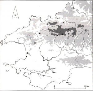
Fig. 3 -Henges, stone circles and stone rows.
Henge (diamond), stone circle (circle),stone row (triangle).
Solid symbols = probable sites.. Open symbols = possible sites. Land over 100m and 250m is represented by shaded areas.
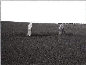
Plate 3 -Standing stone pair.
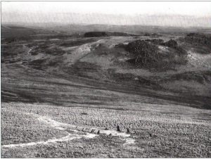
Plate 4 -Stone circle
None of the henge monuments in Pembrokeshire have been excavated, and all four sites are only possible examples of this particular monument form.
Standing stone pair (13 sites, Plate 3) – quite specifically a pair of standing stones located immediately adjacent or within close proximity to one another no more than 15m apart. Often, though not always characterised by a so-called ‘male’ stone (a tall and tapering monolith) and a ‘female’ stone (shorter and more squat). These stones appear to have been purposefully chosen and sited together, and are distinct from a stone row.
Williams has reviewed the evidence for standing stones and standing stone pairs in southwest Wales, 14 although none of the Pembrokeshire examples have so far been excavated. However, given the complexity of features associated with single standing stones (as evidenced by archaeological work at Rhos-y-Clegyrn, St Nicholas 15 and Stackpole Warren),16 it could be reasonably predicted that similar settings, pits, post-holes and areas of charcoal would be discovered if any of these pairs of stones were investigated. In terms of distribution within Pembrokeshire this site type showed the most marked and distinctive distribution pattern, with 10 of the 11 probable sites located exclusively across the Preseli hills, and often in close association with other contemporary ritual monuments.
Stone circle (Fig. 3 – 15 sites, Plate 4) -an approximately circular or oval of setting of spaced, usually free-standing, upright (or originally upright) stones. More than one circle may be present, arranged concentrically. Stone circles may be found in association with other prehistoric monuments such as round barrows, and may themselves be a constituent part of henge monuments. Other features may also be present within stone circles, such as cists or pits, and these monuments are assumed to have had a ritual and possibly funerary function during the late Neolithic and into the middle Bronze Age.
In Pembrokeshire there are eight probable and seven possible sites. The only site recently excavated is the embanked stone circle at Letterston 17 where investigations revealed an inner cairn ring within which there was a circle of stones 12m in diameter, with an entrance and external ritual pit on its east side. Savory interpreted this as an embanked stone circle, to which was later added a turf mound with a kerb 32m in diameter, covering a cremated burial placed in the entrance. 18 This effectively transformed the site from a late Neolithic ‘open’ ritual site to a ‘closed’ early Bronze Age funerary round barrow. Nothing of the stone circle now remains.
Stone row (Fig. 3 – 6 sites) – one or more roughly parallel rows of three or more upright stones set at intervals along a common axis and presumed to have been used for ritual activity during the late Neolithic and Bronze Age.
Two probable and four possible sites are known within the Pembroke shire area. So few examples of this monument type can partially be explained by their overall rarity within southwest Wales in general, although it is likely that more sites once existed. Often, though not always, stone rows were constructed using stones which were much smaller than their standing stone counterparts, thus adding to their vulnerability particularly in areas of intensive agricultural activity. None have been excavated in Pembrokeshire, nor indeed have any in Wales as a whole, so their precise role is uncertain, although many seem to occur in upland locations, in similar landscape settings to stone circles, with which they often seem to be associated.
Round barrow (Fig. 4 – 215 sites, Plates 5 and 6) – a round mound of earth and/or stone with a rounded or flattened top presumed to be for burial and other ritual activity during the later Neolithic or Bronze Age. The mound may be enclosed by a circular or intermittent outer ditch and may have a complex structure including stone kerbs, stone settings or burial cists. Such internal and external features are rarely recorded unless excavated.
This site type is the most commonly found prehistoric funerary and ritual monument, with 162 probable barrows and 53 possible sites now recorded in Pembrokeshire alone. In addition to the 215 sites visited during the PFRS project, a further 79 round barrows are recorded from place-name and documentary sources. Despite their abundance, very few
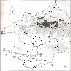
Fig. 4 – Round barrows.
Solid symbols = probable sites. Open symbols = possible sites. Land over 100m and 250m is represented by shaded areas.
of these Pembrokeshire round barrows have been fully excavated, and Parc Maen, Llangolman is the only one to have been investigated recently using modem scientific techniques. 19 The site was found to consist of a cairn, 18m in diameter, with evidence for some kerbing on its northeast side, with various associated features including charcoal filled pits, post-holes, seven small standing stones, various pottery vessels and lithic artefacts.20 Radiocarbon determinations produced a date range of c.2100BC to 1610BC from a number of charcoal deposits, suggesting that the site may well have been in use for some 500 years. There was also palaeoenvironmental evidence gathered from the site, suggesting the selective use of oak over other species. Evidence from the body of the cairn and the features associated with it suggested that there was a primary inhumation burial in a shallow pit, with a number of
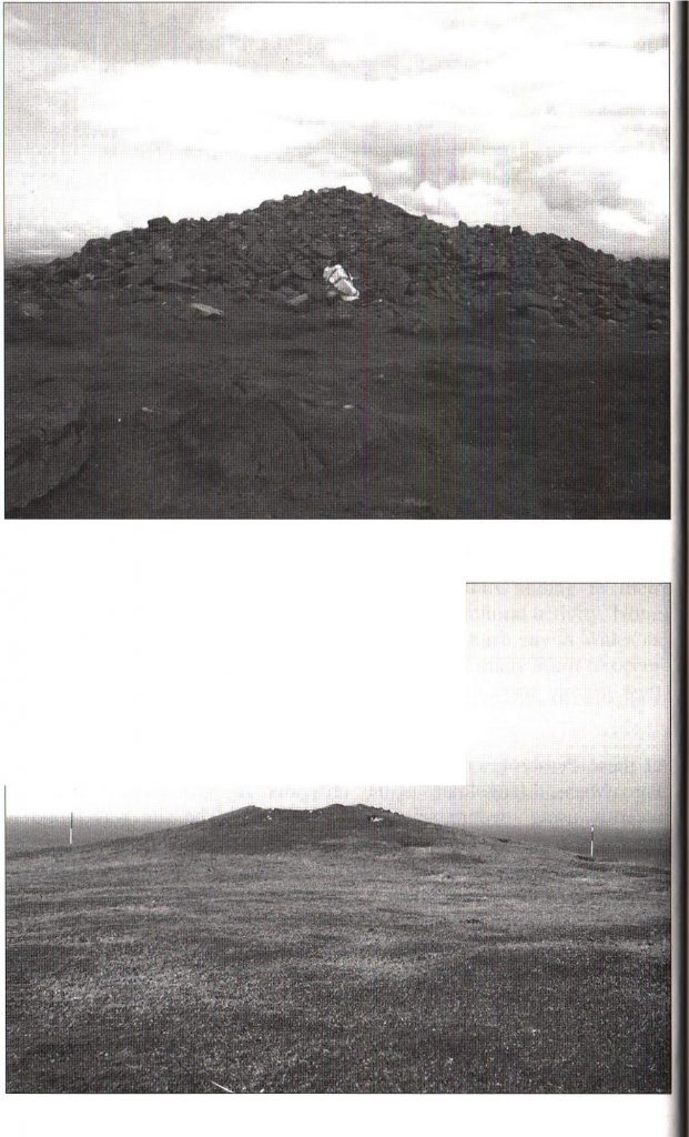
Plates 5 and 6- Round barrows.
secondary cremations inserted later into the cairn as indicated by the remains of some fragmentary pottery vessels. Unfortunately the acid nature of the soil meant that no burial remains survived for analysis. An earlier watching brief at the site prior to the rescue excavation revealed an inverted Beaker in a pit 1OOm to the north of the site, which would a l most certainly have originally contained a cremation burial.21 In general round barrows were no longer built or used for ritual/funerary activity after the middle Bronze Age, although the later Bronze Age in Britain (from c.1100-700BC) saw a trend towards the re-use of round barrows, with many sites becoming the focus for fresh secondary burials, although so far there is no evidence for this in south-west Wales.
Ring barrow (24 sites) – a monument comprised of a ring of earth and/or stones, ranging in Pembrokeshire between 5 and 30m in diameter, surrounding a hollow central area that is (or was initially) free of cairn material, and which is presumed to have been the focus of various prehistoric ritual ceremonies during the later Neolithic and Bronze Age.22
There are 5 probable and 19 possible ring barrow sites in Pembrokeshire, with a marked clustering over the Preseli hills between Crymmych and Fishguard . Unfortunately none of the sites in Pembrokeshire have been excavated. However, in north Wales several have been investigated, with Brenig 44 a particularly good example.2′ Ring barrows, although linked with the burial of the dead, also demonstrate a wider range of other rituals taking place within their confines, suggesting that they were perhaps more orientated towards other kinds of ceremonial activity, with actual burial deposits a later development. The radiocarbon sequence for Brenig 44 suggests that the site was in use for between 500 and 600 years (between c.2170-1447BC), with repeated pits dug against the inner edge of the ring and filled with pure charcoal.24 It is possible that rituals involving the burial of charcoal were making symbolic references to the funeral pyre used for cremating the dead, which negated the need for actual cremation burials to be made. Three burials were eventually made at the Brenig ring cairn, however, suggesting a change in its emphasis, but not until much later on in its ritual usage. Similar results were also obtained from Moel Goedog25 where repeated episodes of burying charcoal occurred throughout the 200-year history of the site, but with a ‘standard’ burial only occurring much later.
Cist (3 sites) – an isolated stone pit assumed to have held a human burial of prehistoric or later date. Generally cists take the form of rectangular structures built from stone slabs set on edge and covered by one or more horizontal slabs or capstones.
The small number of sites recorded in Pembrokeshire is likely to result from the fact that such features represent ‘flat ‘ burials with little or no surface indication of their presence, and thus tend to be only encountered by chance.
Cremation burial (3 sites) – a single cremation burial, in which the human body is burnt leaving fragmentary charred or completely combusted remains, possibly contained within a pit and/or pottery vessel. Such burials may be accompanied by grave goods, but generally have no associated surface features . They are distinct from cremation burials associated with round barrows, henges or other funerary and ritual monuments. They occur during the later Neolithic to middle Bronze Age, and again in the later Iron Age and Romano/British period.
As with cist burials, such a small number of’ known cremation burial sites in Pembrokeshire is likely to be the result of’ the little or no surface indications of their presence, with the recorded examples known having been found by chance. Once found, these burials are usually removed from their location and housed in museums or other collections, and are recorded on the SMR as ‘finds’ with no further archaeological presence in the landscape. None of these sites were therefore visited during fieldwork.
Stone setting (2 sites) – an imprecise term referring to an arrangement of upright stones that is not readily identifiable as either a stone circle, stone row or any other well-defined type of megalithic monument.
There are two such sites in Pembrokeshire: one known as ‘The Ketch’ and described by Fenton in 1811, 26 which refers to an arrangement of stones possibly enclosed within the henge at Letterston; and, secondly, the five standing stones and one recumbent surrounding the ruined chapel at St. Non’s, near St. David’s.
Cursus (1 site) – a markedly long and narrow ditched enclosure with parallel sides associated with ritual activity of Neolithic date and often associated with other funerary monuments of Neolithic or Early Bronze Age date. The only examples currently falling within the monument type definition in Wales are known from cropmark evidence, although earth works defined by a bank and external ditch are known elsewhere in the British Isles.
Only one possible cursus monument has been identified in the county at Llandissilio, on the border between Pembrokeshire and Carmarthenshire. The site was identified from aerial photographs, but there were no above surface indication s of the site when visited in the field. However, the site lies close to the well-known monument complex at Glandy Cross just over the county boundary, which comprises the Meini Gwyr embanked stone circle, possible round, ring barrows and standing stone, as well as a rhyolite axe factory.27 So far, this cursus at Llandissilio is the only known monument of its type in southwest Wales.
Pit circle ( 1 site) – one or more concentric circular settings of pits identified from cropmarks or excavation, and considered to be associated with funerary or ritual activity of later Neolithic or early Bronze Age date. Excavation may show that a site should be re-classed as a timber circle or stone circle, but might otherwise represent a circle of cremation or votive pits.
There is one example of this site type in Pembrokeshire, known from cropmark evidence, at Cottesmore, Rudbaxton, The site looks very impressive on aerial photographs and is protected as a Scheduled Ancient Monument. No excavation has taken place here, however.
Group monument types
The following groups of monuments are recorded in the SMR as site type s in themselves, but act as hierarchical terms for a closely associated set of individual monuments. Each individual monument already has its own record number, but the group monument record number allows inter-related monuments to be recognised as a cluster which would not otherwise be possible when searching the SMR database. In addition to the pre-existing ‘Chambered tomb cemetery’ and ‘Round barrow cemetery’ terms, two new group monument types were created (Prehistoric Monu ment Complex’ and ‘ Round Burrow Pair) and added to the SMR as a result of this project. A number of previously unrecorded round barrow cemeteries were also recognised from both the desk-based assessment and fieldwork and also added to the database.
Chambered tomb cemetery(Fig 5 – 4 sites) – as the name suggests, a group of chambered tombs located within close proximity to one another.
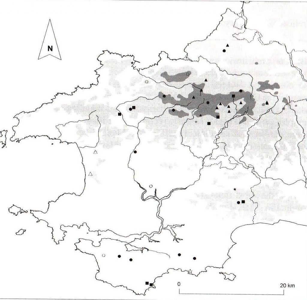
Fig. 5/Plate 7 – Group monuments. Chambered tomb cemetery (star). Standing stone pair (triangle). Round barrow cemetery (circle). Monument complex (square).
Solid symbols = probable sites. Land over 100m and 250m is represented by shaded areas.
There are three probable sites and one possible cemetery in Pembrokeshire. Unfortunately the three (and possibly four) chambered tombs at Eithbed West, Maenclochog, were largely destroyed in 1911 and all that remains or the tombs now are some large stones cleared to the field boundary. The tombs at Pen-lan, Lampeter Velfrey, are equally in a state of disrepair. However, the best preserved example of a chambered tomb cemetery are three excellent chambered tombs and possible fourth at Garn Wen, Goodwick, which are located on the eastern side of a rock outcrop on land accessed by public footpath. 28
Prehistoric monument complex (Fig. 5 – 9 sites) a pair or group of different types of prehistoric funerary and/or ritual monuments, which are perceived as having some association. An example would be a round barrow and standing stone in close proximity, or a group i1ncluding a wider range of monuments (e.g. a long barrow and chambered tomb cemetery, or a standing stone, ring barrow and two round barrows, etc.). This recognition of grouping makes an important contribution to our understandings of the inter-relationships and patterns of association between different monument types throughout the Neolitltic and Bronze Age.
Within Pembrokeshire there are a number of well-known complexes, including Stackpole Warren in the south of the region, and Letterston in the northwest. There is also a cluster of complexes within the Preselis. Unfortunately access to the Glyn-y-Fran complex was not possible during the PFRS project, but it is believed that the complex consists of four ring barrows or ring ditches with flaked stone artefacts found in association with the sites when the area was fieldwalked in 1989. Of the remaining eight prehistoric monument complexes recognised during the fieldwork phase of the project, all contain a varying range and number of different prehistoric monuments within their spectrum. At Newhouse, there are four round barrows, one ring barrow and a standing stone. Both the Stackpole Warren complexes in south Pembrokeshire and the complex at Carn Menyn , located in the Preseli hills in the north of the county, each comprise two round barrows and a standing stone, with the complex at Ty-Newydd, Mathry, recording the association between one round barrow and standing stone. At Parc Maen, Llangolman, the complex consists of two standing stones, a round barrow and a whole series of post-holes, charcoal- filled pits and stone settings, which were excavated under salvage conditions by Cambria Archaeology (Dyfed Archaeological Trust) in 1981-2. 21 However, the complexes at Letterston and Prisk are perhaps the most interesting and multi-phase prehistoric sites recorded within the SMR for Pembrokeshire. At Letterston the complex comprised three round barrows, one of which was originally an embanked stone circle, a single standing stone, and a ‘trilithon’ triangular arrangement of stones (perhaps the remains of a stone circle) which was once possibly located within a circular earthwork, itself a potential henge. All of the monuments were built on a NE-SW alignment, and suggest that the area was a focus for continuous ritual activity during the later Neolithic and early Bronze Age. 30 At Prisk, Maenclochog, the monument complex consisted of a huge earthwork (henge?) which enclosed the remains of one, and possibly two, chambered tombs, and up to four standing stones, with the henge covering an area some 400m x 250m. With the exception of the complexes at Stackpole and Ty Newydd , all the remaining prehistoric monument complexes were located on land above 100m, with that at Carn Menyn the highest at 335 m. Both the complexes at Stackpole were intervisible with each other and all the sites within them overlooked the sea.
Round barrow cemetery (Fig. 5 – 19 sites) – for this survey a group of three or more round barrows were classed as a cemetery, on the basis that they exist within close proximity to one another: few will be more than 150m from their nearest neighbour and most will be less than 100m apart.31
In total, there are 13 probable barrow cemeteries and six possible cemeteries in Pembrokeshire, the possible sites being those which are largely destroyed or known only from documentary sources. Nine sites were located within the Preseli hills, six of which were located on land above 250m. There were fantastic views achievable from these sites, and they were also located in prominent locations, which often dominated the viewshed from a number of other PPR sites. Another band of round barrow cemeteries form an east-west alignment in the far south of the county, roughly between Tenby and Angle, seemingly following the line of ‘The Ridgeway’, which was possibly an ancient trackway through the landscape around which these barrow cemeteries were focussed. Good examples of this site type can be visited at Foel Drygarn and Frenni Fawr.
Round barrow pair (12 sites) – a clear pairing of two round barrows sited within close proximity of each other, usually within 100m, and distinct from individual round barrows and barrow cemeteries. Often, though not always, the two barrows will be of similar size and construction, suggesting they were deliberately paired together and were not simply the result of an unfinished cemetery or intended larger grouping. This twinning of round barrows may reflect a regional tradition, which is also represented by ‘standing stone pairs’.
In Pembrokeshire there are 9 probable and 3 possible pairs of round barrows, mostly located in very prominent locations in the landscape, notable examples including the pairs at Crugiau Dwy and Mynydd Castlebythe. On Plumstone mountain there are two pairs of barrows located 400m apart from each other on an east-west alignment. Of the remaining sites, many are located on local summits and ‘high’ places within the more lower-lying land of the county, suggesting that as with round barrow cemeteries, prominent landscape locations were a key factor in the siting of these monuments.
DISCUSSION
The overall distribution of all monument types within Pembrokeshire shows a relatively even spread of prehistoric funerary and ritual monuments across the county, suggesting that during the Neolithic and Bronze Age the landscape was both populated and popular with monument builders and users. However, there seem to be two bands across the county where monuments are slightly more dense in distribution: one band occupies the northern third of Pembrokeshire from the Preseli hills across to St David’s with the majority of sites located on land 100m and above; the second band is located in the most southerly part of the region below a line between Tenby and Angle Buy. In south Pembrokeshire, whilst the land lies below 100m, there are a number or gentle spines running roughly east-west across this area, and it is upon these spines that the majority of monuments are focussed. The Ridgeway is a well – known example of this, and is likely to have been a prehistoric trackway across this part of the county, which may account for the clustering of monuments along its length. The ‘banding’ of monuments noted above is particularly noticeable in the distribution of group monument types (see figure 5). It is possible that the bias in the record could be explained by a partiality in preservation, although it must also be considered that certain prehistoric funerary and ritual monuments were deliberately not built in some areas. Analysis of the topographical siting recorded for both individual and group monument types during field work suggested that hill slopes were by far the most preferred locations for the majority of sites, particularly in the case of chambered tombs and standing stones, with 242 sites in total recorded as having hill slope locations. However, some variations between different monument types are suggested by the data. For example, 68 round barrows are located in ‘ hilltop’ locations (defined as either summits, local summits, ridges or high plateaux) compared to only 11 standing stones recorded in such locations. 73 % of standing stones are, however, located on hill slopes, compared to 29% of round barrows. 76% of chambered tombs are recorded on hill slopes, with only 2 sites having ‘hilltop’ locations. It has been suggested that standing stones in southwest Wales are generally sited within the lower one-third of the altitudinal range of a given area. 32 However, the topographic location of sites in Pembrokeshire suggests a rather more variable location. Nonetheless, there does appear to be different locational criteria for the siting of the three largest groups of monuments, which is no doubt linked to their different symbolic meanings and their reflection of different traditions of monument construction and usage from the early Neolithic through to the middle Bronze Age.
When comparing and contrasting the locational patterns of individual monument types in more detail, a number of interesting trends emerge. For example, with the exception of the three most well-represented types of monuments (chambered tombs, standing stones, and round barrows) the majority of the remaining site types are almost exclusively found within the northern half of Pembrokeshire, and for the most part favoured locations on land above 100m. Apart from the one possible cremation cemetery at South Hills (known only from antiquarian documentary sources), located just north of the Ridgeway in south Pembrokeshire, the other remaining cist and cremation sites are all located in an east-west band across the Preseli hills from Pantgwyn in the east across to Tremynydd, near St Davids, in the west. The four possible henge monuments are all located in the northern portion of the county, with potential sites near Letterston, Clarbeston, Maenclochog and Pentre Galar. With the exception of the possible stone row near Dale (which is more likely to be the result of glacial deposition), the remaining stone row sites near Abercastle, Manorowen, Llanychaer, Puncheston, and Eisteddfa, are, too, concentrated in the north of the region, and again form a band across the Preseli hills. However, whilst the majority of stone circles in Pembrokeshire are indeed located in the north of the region, with a concentration of well-known extant examples on the Preseli hills such as Gors Fawr and Bedd Arthur, there is a generally wider spread of this monu ment type in Pembrokeshire compared with what has been seen for cists, cremations, henges and stone rows. For example, there are probable stone circle sites to the southwest of the Preselis at Plumstone and Treffgarne, and also towards the coast at Druidston and Haroldston West, with other possible stone circles occurring near Hundleton, and also at Brunt Farm near Dale, where two Neolithic stone axes were found (now housed in Tenby Museum). Both sites are located in the south of the county, but unfortunately no traces of these monuments survive today.
In Pembrokeshire, as noted earlier, the three most commonly found monument types are chambered tombs, standing stone and round bar rows. Chambered tombs are the earliest known prehistoric funerary and ritual monuments found in the county, and have been extensively studied and interpreted, their sheer density comparable only to Anglesey and the Cotswolds.33 Their interpretation and classification has been debated and contested for many years, 34 and these enigmatic monuments continue to be a source of fascination. Links along the Irish seaboard have been suggested, with external influences of monument building perhaps being fused with local landscapes and mythologies, resulting in their problematic typological analysis and classification today. The unique nature of some of the Pembrokeshire sites (e.g. Cerrig y Gof and other ‘earthfast ‘ examples such as Carn Wnda) compares with the more widely recognised portal-dolmen type, as demonstrated by Pentre lfan and Carreg Coetan Arthur, known else where in parts of northwest and south east Wales.35 The majority of probable chambered tombs in Pembrokeshire lie within the northern half of the county although none are sited on land above 250m. More clearly noticeable, however, is that all chambered tomb sites seem to be specifically located near sources of water, being sited on the coast and following the major rivers. They often either overlook the sea, or are sited close to springs, streams, or with glimpses of the sea as dictated by the surrounding topography. No other monument type in Pembrokeshire so clearly demonstrates this particular relationship between water and site location.
Standing stones are the second largest group of prehistoric funerary/ ritual monuments represented in Pembrokeshire. In terms or distribution, two bands of probable sites are visible which show a greater density of stones located above a line running from the coast at St Davids across to the Carmarthenshire border at Llanwinio in the north , and secondly below a line running from Tavernspite to Marloes in the south of the region. However, it is interesting to note the relative paucity of standing stone sites in the middle band of the county, where so far only possible standing stone sites have largely been recorded. 36 Such stones are recorded only as possible stones because of a lack of certainty about their authenticity : some of the stones are no longer extant, others have bee n moved or re-used, whilst others are possible rubbing stones. Only excavation of these sites would be likely to solve the puzzle. The distribution of standing stone pairs, however , a seemingly regional variation in monument building within southwest Wales, is considerably more distinct. The re are 11 probable sites in Pembrokeshire and all are clustered on Mynydd Preseli (with the exception of the pair near Moylgrove, which had originally been recorded as a possible chambered tomb) and most are intervisible with other prehistoric monuments, in particular with other standing stones. In addition there is a stone pair associated with the stone circle as Gors Fawr, whilst at Cerrig Lladron the stone pair there is intervisible with the round barrow on Foel Eryr.
The most common prehistoric funerary and ritual monument type in Pembrokeshire, and indeed for the whole of the former Dyfed region, are ’round barrows’. The term ’round barrow’ covers a wide variety of different monument sizes and composition, with some barrows composed purely of stone, although they are more usually are an admixture of both stone and earth in varying proportions. Round barrows are equally varied in size and height, but hold in common a usually clearly defined circular shape. Sometimes, where preserved, a rounded profile is also evident, although these monuments assumed a variety of different forms (rounded, flat-topped, low, small, high, large, kerbed, capped), which would undoubtedly have played a role in their ritual usage and their ‘monumentality’. These differing types of round barrow form may potentially reflect localised traditions, but equally may be deliberate variations on a symbolic, social and cultural level, especially where these different forms are closely associated in the landscape. In terms of topographic siting, extant round barrows favour upland locations, for the most part in prominent positions with commanding views out over the wider land scape. Intervisibility between other sites, and in particular between other round barrows, seems also to play a large part in determining their exact positioning. Unlike the other monument types, which are less well represented in the middle band of the county, a greater number of individual round barrows are known from the more lowland contexts in this middle portion, but their preservation is varied. Many have been plough-levelled, but have traces still visible, whereas others are now known only from documentary sources. It is possible that round barrows have survived better in the more intensively farmed middle band of the county as they are less easy to remove than, for example, standing stones. Despite a more even distribution of round barrows within the county, there is still a greater concentration of these monuments in the north across the Preseli hills, although a degree of clustering is also visible in the south. There is a distinct band of round barrow sites seemingly focussed along the line of the Ridgeway in south Pembrokeshire, with a further clustering of sites at Castlemartin/Brownslade and Stackpole/Bosherston. A second band of barrows follows another ‘spine’ of land from Dry Burrows in the east to below Angle Bay to the west. As groups of sites, round barrows in cemeteries are almost exclusively located on high ground, and often dominate the skyline for miles around. Particularly good examples of this include the round barrow cemeteries on top of Foel Drygarn and Foel Cwmcerwyn, located on the highest points of the Preselis. There are also four separate round harrow cemeteries in the south of the region, at Bier Hill, Hodgestone Hill, Orielton and Wallaston, with another possible cemetery at Kilpaison. Together these form an east-west band focussed again on the Ridgeway and from Dry Burrows to south of Angle. The extensive views that were achievable from these sites, despite their seemingly more low- lying location on the distribution maps, suggests that panorama over the surrounding landscape was a crucial factor in deciding their precise location.
The nine prehistoric monument complexes so far recorded also demonstrates that the grouping together of more than one type or prehistoric monument was not an entirely uncommon practice in Pembrokeshire, and suggests the deliberate creation of more localised ritual landscapes which were in use for many hundreds or years. From many of these groups of sites it was not only possible to see the othe r monuments within the immediate group but it was also possible to look out over to other prominent locations in the landscape where other groups of sites were also present.
A clear pattern which emerges from the above discussion is the apparently careful choosing of quite specific locations for the siting of different individual monument types. This was especially seen within the locational analysis of chambered tombs. Intervisibility between sites was a pattern also clearly observed during the fieldwork phase: even if the actual monuments themselves were not directly visible, their locations certainly were. It is hoped that these observations can be further tested in order to see if they are statistically valid by applying techniques used within Geographic Information Systems (GIS) such as digital terrain modelling and visualisation studies (e.g. such as those applied at Stonehenge).73 As a result of the PFRS project in Carmarthenshire, a preliminary examination of topographic location, cost surface analysis and viewshed using GIS was recently applied to a small selection of monuments within the Upper Tywy valley 38 with very promising results. The Preseli hills in particular appear to be a magnet for prehistoric activity, but although the area of the Preselis is undeniably a significant ritual landscape in the Neolithic and Bronze Age, (and as a result tends to receive greater attention in archaeological discussion (see, for example, the SPACES project), 39 the south of the county should not be forgotten as being a significant area in its own right.
There is no escaping the fundamental relationships which seem to have existed between the natural and cultural worlds in the prehistoric past, and a variety of literature has been produced offering various interpretations as to what these monuments might ‘mean’.40 Many of the monuments looked out over huge swathes of undulating landscape dominated inland by the major valleys of the Cleddau and by the upland blocks in the north of the region across the Preselis, whilst not forgetting that the greater proportion of the county is dominated by its coastline. As we have seen, the location of sites appeared to make specific reference to significant natural elements such as water. Monuments were often located close to natural springs or small streams, or were actually directly overlooking rivers or the sea. A number of monuments were also located in waterlogged and boggy areas in the landscape as if to further re-affirm a connection between ritual practice and natural elements. Such sites offer the chance for palaeoenvironmental research, which informs our understanding of what the landscape might have looked like through analyses of pollen cores and samples, and can tell us what species flourished at that time.
As this project develops it will be interesting to compare these patterns with those already seen in Carmarthenshire 41 and Ceredigion,42 where fieldwork is currently being undertaken . It is hoped that the work undertaken during the course of the PFRS project will contribute to a wider understanding and interpretation of the nature and significance of ritual and funerary monuments in the prehistoric past, and in association with the other Welsh Archaeological Trusts and Cadw, will enable the development of a regional and national perspective on Neolithic and Bronze Age monumentality in Wales.
Acknowledgements
The project and this paper were undertaken with the assistance of Richard Ramsey (fieldwork) , Marion Page (SMR), and Ken Murphy, with thanks also to Gwilym Hughes, Sian Rees and Kate Robets. The fieldwork aspect was facilitated by the co-operation and kindness or the numerous landowners and farmers who gave permission to access the monuments on their land, and also by those who contributed their local knowledge, which was often enlightening. The project was funded by a grant from Cadw. Illustrative maps were kindly produced by Ken Murphy.
Published with the aid of a grant from Cadw.
Notes
- A pilot project was undertaken by Clwyd-Powys Archaeological Trust (CPAT) in 1997 to examine Neolithic and Bronze Age funerary and ritual monuments in the Upper Severn Valley. During this project a preliminary working methodology and glossary of terminology were developed (A.M. Gibson, Prehistoric Funerary and Ritual Sites: Upper Severn Valley, (unpublished CPAT Report 277, 1998)). Similar surveys by CPAT followed for sites in Denbigh & East Conwy during 1998-9 (N. W. Jones, Prehistoric Funerary and Ritual Sites: Denbighshire & East Conwy (unpublished CPAT Report 314, 1999)) and Flintshire & Wrexham during I 999-2000 (N. W. Jones, Pre historic Funerary and Ritual Sites: Flintshire and Wrexham (unpublished CPAT Report 351, 2000)). The funding for this Prehistoric Funerary and Ritual Sites project was extended during 2000-2001 to facilitate the first of a series of surveys undertaken by the three other Welsh Archaeological Trusts, with all the work having been funded by Cadw.
- There is, however, in Pembrokeshire a number of key Neolithic/Bronze Age settlement sites such as Clegyr Boia (A. Williams, ‘Clegyr Boia, St David’s (Pembs): Excavation in 1943’, Archaeologia Cambrensis, 52, (1952), 20-47), Stackpole Warren (D. G. Benson, J. G. Evans, G. H. Williams, T. Darvill, and A. David, ‘Excavations at Stackpole Warren, Dyfed’, Proceedings of the Prehistoric Society, 56, (1990), 179-246) and possibly the complex on Skomer Island (J. G. Evans, ‘An archaeological survey of Skomer, Dyfed’, Proceedings of the Prehistoric Society, 56, (1990), 247-269). Recent work by Cambria at Redberth has also revealed stake-built structures supported by radiocarbon dates from charcoal deposits within post-holes fills, which gave a date range of c.3700-2200BC for the site.
- There were no recorded examples of the following site types in Pembrokeshire, although they are recorded as Neolithic and Bronze Age funerary and/or ritual monuments elsewhere within Wales:
Long barrow – earthwork or cropmark indications of a long and roughly rectangular or trapezoidal mound of earth and/or stones, presumed to have been built and used as a funerary and/or ritual monument during the early to middle Neolithic.
Palisaded enclosure – one or more rows of pits identified from crop marks or excavation, forming the perimeter of an enclosure which may be associated with Neolithic funerary or ritual activity.
Pit – a pit or pits of unknown function, usually associated with funerary and ritual monuments of the Neolithic and Bronze Age and identified from cropmark evidence or excavation.
Pit avenue – two parallel rows of pits, possibly originally for upright timbers, forming an avenue. So far, the only known example in Wales is in the Walton Basin in association with a palisaded enclosure (see A. M. Gibson, The Walton Basin Project: Excavation and Survey in a Pre historic Landscape 1993-7 (Research Report 118, York: CBA, 1999)).
Timber circle – sites which have been shown by excavation to have con sisted of one or more concentric settings of upright posts set in individual post-holes associated with funerary and/or ritual activity of later Neolithic or early Bronze Age date. The definition also includes timber circles which may form part of a henge (A. M. Gibson, ‘Excavations at the Sam-y-Bryn-Caled cursus complex, Welshpool, Powys, and the timber circles of Great Britain and Ireland’, Proceedings of the Prehistoric Society, 60, (1994),143-223))
4. S. Rees, ‘Excavations at Carreg Coetan Arthur chambered tomb, Newport, Pembs.’ (Cadw, forthcoming).
5. F. Lynch, ‘Excavations at Carreg Samson Megalithic Tomb, Mathry, Pem brokeshire’, Archaeologia Cambrensis, 124, (1975), 15-35.
6. W. F. Grimes, Pentre–lfan burial chamber, Nevern, Pembrokeshire, (Ministry of Works, HMSO: London, 1960)
7. F. Lynch (1975), 27.
8. Sian:Rees, pers. comm., 16th January 2006
9. C. T. Barker, The Chambered Tombs of South West Wales, (Oxbow Mono graph 14: Oxford, 1992)
10. V. Cummings and A. Whittle, Places of Special Virtue: Megaliths in the Neolithic Landscapes of Wales, (Oxbow Books: Oxford, 2004).
11. A. Fleming, ‘ Megaliths and post-modernism: the case of Wales’, Antiquity, 79 (205), 921-932.
12. D. G. Benson, J. G. Evans, G. H. Williams, T. Darvill, and A. David, ‘Excavations at Stackpole Warren, Dyfed’ , Proceedings of the Prehistoric Society, 56, (1990), 179-24.
Ibid., 190-5.
14. G. H. Williams, The Standing Stones of Wales and South-West England, (BAR British Series l97, Oxford, J988).
15. J. M. Lewis, ‘Excavations at Rhos-y-Clegyrn Prehistoric Site, St Nicholas, Pembs’ , Archaeologia Cambrensis, 1 23, (1974), 13-42.
16. D. G. Benson etal (1990).
17. H. N. Savory, ‘Two middle Bronze Age palisade barrow s at Letterston, Pembrokeshire’, ArchaeologiaCambrensis, I 00, (l948), 67-89 .
18. H. N. Savory, ‘Excavations at a third round barrow at Pen-dre, Letterston (Pembs.) 1961’, Bulletin of the Board of Celtic Studies, 20, (1 963 ), 309-25.
19 E. C. Marshall and K. Murphy, ‘The excavation of two Bronze Age cairns with associated standing stones in Dyfed, Pare Maen and Aber Camddwr II’, Archaeologia Cambrensis, 140, (1991), 28-76.
20. Ibid., 29-40.
21. It is important to note that at most, if not all, prehistoric funerary and ritual monuments, there would have been depositional activity not just at the sites themselves but also in the areas surrounding the sites, although evidence for such activity generally lies below the surface and is encountered only by chance or through excavation..
22. This site type is included by CPAT as a sub-type under the category of round barrow, but it is strongly felt that ring barrows are a distinct monument form in their own right, and have thus remained in the Cambria Archaeology SMR as ring barrows.
23. F. Lynch, Excavations in the Brenig Valley: A Mesolithic and Bronze Age La,ndscape in North Wales (Cambrian Archaeological Association Mono graph 5, Cardiff, 1993).
24. F. Lynch, ‘The Later Neolithic and Early Bronze Age’ in F. Lynch, S. Aldhouse-Green and J. Davies Prehistoric Wales, (Sutton Publishing: Thrupp, 2000), 135.
25. F. Lynch, ‘Moel Goedog Circle I, A complex ring cairn near Harlech’, Archaeologia Cambrensis, 133, (1984), 8-50.
26. R. Fenton, Historical Tour Through Pembrokeshire (London, 1811).
27. T. Kirk and G.H. Williams, ‘ Glandy Cross: a later prehistoric monumental complex in Carmarthenshire, Wales’ , Proceedings of the Prehistoric Society, 66, (2000), 275-95; P. A. Ward, G. H. Williams, E. C. Marshall and I. M. Darke ‘The Glandy Cross Complex’, Archaeology in Wales 27, (1987), 9-12.
28. S. Rees, Guide to Ancient and Historic Wales, Dyfed (Cadw, HMSO, 1992) .
29. E. C. Marshall and K. Murphy (1991).
30. H. N. Savory (1948); H. N. Savory (1963).
31. The English Heritage Thesaurus of Monument Class Descriptions defines a round barrow cemetery as five or more barrows, whilst CPAT define a ceme tery as 2 or more barrows. Cambria Archaeology uses the term ‘ Round barrow pair’ to distinguish pairs of barrows from suggested ‘cemeteries’ of sites, believing that the pairing of sites was a deliberate arrangement, as was also the case with pairs of standing stones (‘Standing stone pairs’), which are distinct from a stone row.
32. Roese: cited in G. H. Williams (1988), 5-6.
33. V. Cummings, ‘The monuments of south-west Wales and their landscape settings’ in V. Cummings and A. Whittle (2004), 24-41.
34. In particular see W. F. Grimes, ‘The Megalithic Monuments of Wales’, Proceedings of the Prehistoric Society, 2 (1936), 106-139; G.E. Daniel, ‘ The Prehistori c Chambered Tombs of England and Wales’ (Cambridge, 1950 ); F. Lynch, ‘Portal dolmens in the Nevern Valley, Pembrokeshire’, in F. Lynch and C. Burgess (eds.), Prehistoric Man in Wales and the West (Adams & Dart: Bath, 1972), 67-84; C. T. Barker (1992); C. Tilley, A Phenomenology of Landscape: Places, Paths and Monuments, (Berg: London, 1994); A. Fleming, ‘Phenomenology and the megaliths of Wales: a dreaming too far?’ Oxford Journal of Archaeology 18, (1999), 119-25; V. Cummings (2004).
35. F. Lynch, ‘The Earlier Neolithic’ in F. Lynch, S. Aldhouse-Green and J. Davies (2000), 42-79.
36. Standing stones as a site type tend to be particularly vulnerable to clearance and land improvement measures, and this may go some way towards account ing for the paucity of sites in more intensively farmed areas.
37. S. Exon, V. Gaffney, A. Woodward, and R. Yorston, Stonehenge Landsca pes: Journeys through real–and-imagined worlds (Archaeopress, Oxford , 2000).
38. A. Davey, ‘ Approaching the determinants of site location: a study of the pre historic funerary and ritual monuments of the upper Tywi valley’, (unpub lished MA project Birmingham: BUFAU, 2002).
39. G. Wainwright and T. Darvill, ‘Strumble-Preseli Ancient Communities and Environment Study (SPACES): First Report 2002’, Archaeology in Wales, 42 (2002); G. Wainwright, D. Morgan Evan, and T. Darvill, ‘Strumble-Preseli Ancient Communities and Environment Study (SPACES): Second Report 2003’ , Archaeology in Wales 43 (2003).
40. Some of the key texts which reflect current interpretive trends and have indirectly informed- this article include: R. Bradley, The Significance of Monum ents: on the shaping of human experience in Neolithic and Bronze Age Europe, (Routledge, London, 1998); M. Edmonds, Ancestral Geographies of the Neolithic: landsca pes, monuments and memory, (Routledge, London, 1999); C. Richards, ‘Henges and water: towards an elemental understanding of monumentality and landscape in late Neolithic Britain’ , Journal of Material Culture l, (1996), 313-336; J. S. Thomas, Understanding the Neolithic, (Routledge, London, 1999); C. Tilley (1994); A. Fleming (1999, 2005).
41. N. J. Bestley, Prehistoric Funerary and Ritual Sites Project: west Carmar thenshire (unpublished Cambria Archaeology Re port 2001/25, 2001); N. J. Cook, E. G. Hughes, N. Page, and R. Ramsey, Prehistoric Funerary and Ritual Sites Project: east Carmarthenshire (unpublished Cambria Archaeology Report 2002/94, 2003); NJ. Cook ‘ Prehis to ric funerary and ritual sites in Carmarthenshire,’ Carmarthenshire Antiquary 39, (2004), 5-21.
42. N. J. Cook, ‘Prehistoric Funerary and Ritual Sites Project: Ceredigion’ (unpublished Cambria Archaeology Report, 2006/32, 2006).